|
May 14-20 is Bike Week in Massachusetts! See what's going on and how you can participate... In the meatime, I thought I'd re-share some of my favorite rides that might help you prepare, get in shape, and get your mind in bike mode. This is, of course, just a starting point...it's all about the adventure, so use this to get started, then blaze your own trail!
click here for link to detailed route map on Google
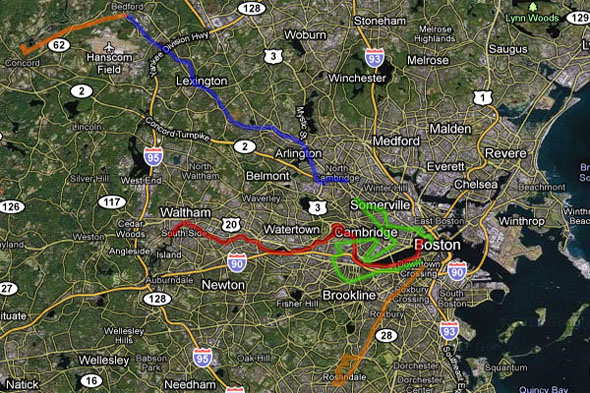
The Minuteman Trail (blue): approx. 11 miles (one way)
One of the most popular bike destinations in Greater Boston, this converted rail route is entirely paved, easy to access, and has limited grade crossings. You can start at Davis or Alewife, then go through both Arlington and Lexington Center, where you can easily stop and refuel if needed. You'll also pass Spy Pond (a great place to chill and watch the water), a bike shop right on the trail (need to stock up on supplies for the midnight ride?), and once you get past Lexington you're in some real nice rural riding (including a bridge over I-95 where you can stop and laugh at those fools stuck in rush hour traffic!). At the very end of the trail in Bedford, treat yourself to a (free!) visit inside a restored Boston & Maine passenger rail car (left).
Reformatory Trail (dark orange, top): approx. 4 miles
If you get to the end of the Minuteman and are feeling particularly adventurish (and Paul-Revere-ish), you can complete the ride all the way to the Old North Bridge in Concord via this unpaved -- but very passable -- path. It likewise runs across an abandoned rail bed, and passes through some really beautiful terrain, including the Great Meadows National Wildlife Refuge. It can be a little rough/muddy in places, and they say the trail is not recommended for road bikes, but I got through as recently as April 3 on a hybrid. Bonus points for screaming "the Redcoats are coming!" as you ride.
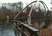 Charles River to Waltham (red): approx. 12.5 miles
There are many ways you can ride along the Charles River (on both sides), but my favorite is along the Esplanade, along Storrow Drive/Soldiers Field Road, along the southern riverbank through Newton, and on the Blue Heron trail all the way to Waltham. Pretty much all paved, with a few (uber-short) sections where you have to ride along the road. You can make a pitstop right across the river in Watertown Square, or at many of the overlooks along the river. You'll be surprised at how quickly the Charles turns into a bubbling brook, and there are some really cool bridges (like the one on the right) and vistas along the Blue Heron trail.
Note that there is currently some minor construction between Galen Street and North Beacon Street. Definitely passable, but be cautious where you see the orange cones (duh). This is a good thing for the future, because they're widening the path along Nonantum Road. Woo hoo!
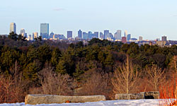 Southwest Corridor to Roslindale/Arboretum (light orange, bottom): approx. 8 miles
Take a journey down through Jamaica Plain and race the adjacent Orange Line trains! This path is a great ride, but beware of errant pedestrians and babies (seriously...strollers abound here). You can start downtown: Columbus Ave (much of which has bike lanes) to Ruggles, where you can hop on the path to Forest Hills. From there, head down Washington Street (which one?!) through quaint Roslindale Village. Then double under the tracks, heft up the STEEP hill to the "backdoor" of the Arboretum, up to the top of Peter's Hill, where you'll find THE coolest view of the Boston skyline (pictured).
Cambervillston (green ): approx. 14 miles
When you're talking about riding through city streets, there are limitless options. I chose to share a biker-friendly path that gives you a taste of several different burghs. I tried to pick a path that contains a lot of bike lanes or otherwise easily navigable paths, so if you're climbing back on your bike after a long winter, it shouldn't be too intimidating. But of course, pick and choose! Explore! Be adventurous!
For this jaunt, I start at North Station, head across to Cambridge, through the new North Point development (avoids the headache that is the O'Brien highway), then up Cambridge Street and back down Beacon/Hampshire. Cross Cambridge on Vassar Street and you'll have a whole dedicated sidewalk to yourself (which, incidentally, is lit up like an airport runway at night...lots o' fun). Then it's straight up stoplight-free Brookline St., onto Mass. Ave., then back down Western Ave into Allston, take a left on North Harvard, a right on Cambridge, a left on Harvard Ave, continue onto Harvard Street, wind through on down to Beacon Street or Comm. Ave., all the way back to Boston Common. It's that easy!
Side Note: the way they name streets around here, there's probably a way you could do the whole route entirely on streets named Beacon, Harvard, and Cambridge. Sheesh!
Got a favorite route of your own? Do share! And of course, don't forget to sign up for the Midnight Marathon Ride...